
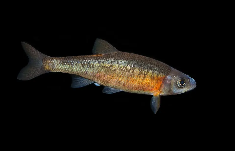
Identification
Rosyside Dace (Clinostomus funduloides) is the binomial used on the GBIF occurrences matched to these waterfalls, in the family Cyprinidae (Cypriniformes).
The common name “Rosyside Dace” is the USGS NAS species-level name for Clinostomus funduloides.
The IUCN category stored on Wikidata is least concern.
The name on each matched record resolves to this binomial. Subspecies and varieties were rolled up to the species. Genus-only identifications were not counted. The GBIF taxon page is Clinostomus funduloides on GBIF.
Waterfalls where it is recorded
Each row is a published waterfall whose nearest named USGS hydrography flowline is the stream in the record, with the flowline within 500 m of the falls and the occurrence within 5 km. Read every row as “recorded in [stream] near [falls].”
| Waterfall | Stream | Records | Years | Distance | Name matched in |
|---|---|---|---|---|---|
| Bradley Falls Tryon, North Carolina | Cove Creek GNIS 983619 | 1 | 2010 | 1.9 km | locality (1) Example: Cove Creek, off SR 1151 [Green River Cove Road], [ca. 9.8 miles ESE center Hendersonville] |
| Bridal Veil Falls Franklin, North Carolina | Cullasaja River GNIS 1010609 | 1 | 2013 | 1.9 km | locality (1) Example: Cullasaja River, upstream of Turtle Pond Road [SR1620], 5.35 km NW of Highlands |
| Carter Falls Elkin, North Carolina | Elkin Creek GNIS 984712 | 1 | 2006 | 1 km | locality (1) Example: Elkin Creek, at SR 2044 [Carter Mill Road], [ca. 3.0 miles NNW center Elkin] |
| Cullasaja Falls Franklin, North Carolina | Cullasaja River GNIS 1010609 | 1 | 2013 | 4.9 km | locality (1) Example: Cullasaja River, upstream of Turtle Pond Road [SR1620], 5.35 km NW of Highlands |
| Dry Falls Franklin, North Carolina | Cullasaja River GNIS 1010609 | 1 | 2013 | 1.3 km | locality (1) Example: Cullasaja River, upstream of Turtle Pond Road [SR1620], 5.35 km NW of Highlands |
| Grassy Creek Falls Spruce Pine, North Carolina | Grassy Creek GNIS 1011630 | 1 | 2012 | 4.7 km | locality (1) Example: Grassy Creek, at SR 1117 [Carters Ridge Road], [ca. 1.4 miles S center Spruce Pine] |
| High Falls Elkins, West Virginia | Shavers Fork GNIS 1552850 | 1 | 2007 | 0.8 km | locality (1) Example: Shavers Fork, at mouth of Red Run, 9 miles east of Dailey WV |
| Moravian Falls Moravian Falls, North Carolina | Moravian Creek GNIS 990213 | 1 | 2008 | 1 km | locality (1) Example: Moravian Creek, just below NC 18, 4.5 miles SSW of Wilkesboro |
| Rainbow Falls Olivet, Tennessee | Dry Creek GNIS 1282928 | 1 | 2012 | 2.8 km | locality (1) Example: Dry Creek at Hitchcock Lane |
Native or nonindigenous status
USGS NAS lists the species-level record as “Native”. That label describes the NAS species record, which can be native in part of the country and introduced elsewhere. The fact sheet is NAS species 511. Counts below are NAS introduction records, not the GBIF counts in the table above.
| State | NAS nonindigenous records | Statuses in the sample | Years in the sample |
|---|---|---|---|
| NC | 10 | collected, established | 2000–2015 |
| TN | None returned | — | — |
| WV | None returned | — | — |
NAS public responses are capped, so statuses and years describe the records returned (up to 100 per state), while the count is the number NAS reported. A state with no NAS row is not marked native.
Fishing rules in these states
These links go to the state agency fishing pages, reviewed 2026-11-19. Seasons, limits, and which streams are open change, and a waterfall record is not a statement that fishing is legal there.
Sources for the occurrence counts
- NCSM Ichthyology Collection — 4 matched records, via GBIF (CC0 1.0 or CC BY 4.0 or CC BY 3.0 or CC BY 2.0 only).
- Auburn University Museum Fish Collection — 3 matched records, via GBIF (CC0 1.0 or CC BY 4.0 or CC BY 3.0 or CC BY 2.0 only).
- GBIF dataset — 1 matched record, via GBIF (CC0 1.0 or CC BY 4.0 or CC BY 3.0 or CC BY 2.0 only).
- University of Alabama Ichthyology Collection — 1 matched record, via GBIF (CC0 1.0 or CC BY 4.0 or CC BY 3.0 or CC BY 2.0 only).
Accessed 2026-11-19. Records before 2005, records with coordinate uncertainty over 5 km, and records whose license was not CC0 or CC BY were excluded. Please cite the original datasets if you reuse the figures.
Frequently Asked Questions
Where has Rosyside Dace been recorded near waterfalls on this site?
In Cove Creek near Bradley Falls, NC; Cullasaja River near Bridal Veil Falls, NC; Elkin Creek near Carter Falls, NC; Cullasaja River near Cullasaja Falls, NC; and 5 more published falls. Each match is a CC0 or CC BY occurrence from 2006–2013 that names the stream and falls within 5 km of the mapped waterfall.
Does that mean Rosyside Dace lives in those waterfalls?
No. The records show the species was recorded in the named stream near the falls. They do not show which side of the drop the animal was on, and they are not a population estimate.
Is Rosyside Dace native in these states?
USGS NAS has nonindigenous records in NC. NAS returned no nonindigenous record for TN, WV. That absence is not a native-range finding.
Can you fish for Rosyside Dace at these waterfalls?
License and season rules are set by the state, not by this site. Agency pages we checked on 2026-11-19: North Carolina (https://www.ncwildlife.gov/fishing); Tennessee (https://www.tn.gov/twra.html); West Virginia (https://wvdnr.gov/fishing/). Confirm the water is open and what gear is legal before you fish.
Which datasets are these counts from?
NCSM Ichthyology Collection (4 records); Auburn University Museum Fish Collection (3 records); GBIF dataset (1 record); University of Alabama Ichthyology Collection (1 record). All of those rows reached us through GBIF under a CC0 or CC BY license. Dataset pages: https://www.gbif.org/dataset/2a79f202-3f3a-4d54-88fa-09aa8de1ac73, https://www.gbif.org/dataset/d499aef2-b1d9-4890-aeb3-5f0d1237b513, https://www.gbif.org/dataset/813b435e-f762-11e1-a439-00145eb45e9a, https://www.gbif.org/dataset/e90a588b-0eed-4077-8a4f-7e61da35b3f8.