
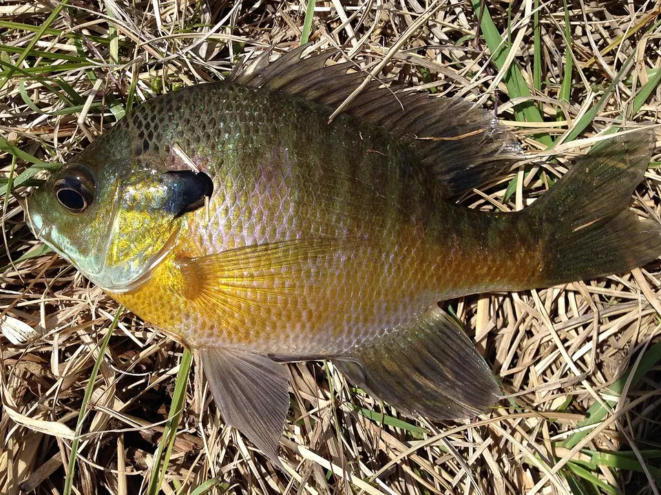
Identification
Bluegill (Lepomis macrochirus) is the binomial used on the GBIF occurrences matched to these waterfalls, in the family Centrarchidae (Perciformes).
The common name “Bluegill” is the USGS NAS species-level name for Lepomis macrochirus.
The IUCN category stored on Wikidata is least concern.
The name on each matched record resolves to this binomial. Subspecies and varieties were rolled up to the species. Genus-only identifications were not counted. The GBIF taxon page is Lepomis macrochirus on GBIF.
Waterfalls where it is recorded
Each row is a published waterfall whose nearest named USGS hydrography flowline is the stream in the record, with the flowline within 500 m of the falls and the occurrence within 5 km. Read every row as “recorded in [stream] near [falls].”
| Waterfall | Stream | Records | Years | Distance | Name matched in |
|---|---|---|---|---|---|
| Chalk Ridge Falls Belton, Texas | Lampasas River GNIS 1374458 | 8 | 2008–2012 | 3.6–3.7 km | locality (8) Example: Lampasas River at Belton |
| Great Falls Smiths Station, Alabama | Little Uchee Creek GNIS 00152117 | 7 | 2005–2011 | 0.1–4.3 km | locality (7) Example: Little Uchee Creek, road crossing CR 179 |
| Cane Creek Falls Dahlonega, Georgia | Cane Creek GNIS 354977 | 2 | 2010–2019 | 2.9 km | locality (2) Example: Chestatee-Chattahoochee-Apalachicola Drainage, Cane Creek, at GA Hwy 9. (TJN19-21) |
| Gorman Falls San Saba, Texas | Gorman Creek GNIS 1358198 | 2 | 2017 | 0.3 km | locality (2) Example: Colorado River at Colorado Bend State Park, just below mouth of Gorman Creek |
| Kinlock Falls Haleyville, Alabama | Hubbard Creek GNIS 00159819 | 2 | 2017 | 3.1 km | locality (2) Example: Hubbard Creek, ~135 m upstream of confluence with Thompson Creek, Bankhead National Forest |
| Lower McKinney Falls Austin, Texas | Onion Creek GNIS 1375298 | 2 | 2013 | 0 km | locality (2) Example: Onion Creek at McKinney Falls State Park, lower falls |
| American Falls Niagara Falls, New York | Niagara River GNIS 958547 | 1 | 2015 | 4.8 km | water body (1) Example: Niagara River |
| Bridal Veil Falls Niagara Falls, New York | Niagara River GNIS 958547 | 1 | 2015 | 4.8 km | water body (1) Example: Niagara River |
| Butcher Falls Sedan, Kansas | Pool Creek GNIS 469501 | 1 | 2010 | 3.9 km | locality (1) Example: Pool Creek |
| Niagara Falls Niagara Falls, New York | Niagara River GNIS 958547 | 1 | 2015 | 4.8 km | water body (1) Example: Niagara River |
Native or nonindigenous status
USGS NAS lists the species-level record as “Native”. That label describes the NAS species record, which can be native in part of the country and introduced elsewhere. The fact sheet is NAS species 385. Counts below are NAS introduction records, not the GBIF counts in the table above.
| State | NAS nonindigenous records | Statuses in the sample | Years in the sample |
|---|---|---|---|
| AL | None returned | — | — |
| GA | None returned | — | — |
| KS | 100 | established | 1995–2014 |
| NY | 100 | established, unknown | 1970–2013 |
| TX | 20 | stocked, established | 1951–2020 |
NAS public responses are capped, so statuses and years describe the records returned (up to 100 per state), while the count is the number NAS reported. A state with no NAS row is not marked native.
Fishing rules in these states
These links go to the state agency fishing pages, reviewed 2026-11-19. Seasons, limits, and which streams are open change, and a waterfall record is not a statement that fishing is legal there.
- Alabama fishing regulations
- Georgia fishing regulations
- Kansas fishing regulations
- New York fishing regulations
- Texas fishing regulations
Sources for the occurrence counts
- Auburn University Museum Fish Collection — 9 matched records, via GBIF (CC0 1.0 or CC BY 4.0 or CC BY 3.0 or CC BY 2.0 only).
- GBIF dataset — 6 matched records, via GBIF (CC0 1.0 or CC BY 4.0 or CC BY 3.0 or CC BY 2.0 only).
- Fishes of Texas Project — 6 matched records, via GBIF (CC0 1.0 or CC BY 4.0 or CC BY 3.0 or CC BY 2.0 only).
- Royal Ontario Museum Ichthyology (ROMI) — 3 matched records, via GBIF (CC0 1.0 or CC BY 4.0 or CC BY 3.0 or CC BY 2.0 only).
- GBIF dataset — 1 matched record, via GBIF (CC0 1.0 or CC BY 4.0 or CC BY 3.0 or CC BY 2.0 only).
- NCSM Ichthyology Collection — 1 matched record, via GBIF (CC0 1.0 or CC BY 4.0 or CC BY 3.0 or CC BY 2.0 only).
- Fort Hays Sternberg Museum Ichthyology Collection — 1 matched record, via GBIF (CC0 1.0 or CC BY 4.0 or CC BY 3.0 or CC BY 2.0 only).
Accessed 2026-11-19. Records before 2005, records with coordinate uncertainty over 5 km, and records whose license was not CC0 or CC BY were excluded. Please cite the original datasets if you reuse the figures.
Frequently Asked Questions
Where has Bluegill been recorded near waterfalls on this site?
In Lampasas River near Chalk Ridge Falls, TX; Little Uchee Creek near Great Falls, AL; Cane Creek near Cane Creek Falls, GA; Gorman Creek near Gorman Falls, TX; and 6 more published falls. Each match is a CC0 or CC BY occurrence from 2005–2019 that names the stream and falls within 5 km of the mapped waterfall.
Does that mean Bluegill lives in those waterfalls?
No. The records show the species was recorded in the named stream near the falls. They do not show which side of the drop the animal was on, and they are not a population estimate.
Is Bluegill native in these states?
USGS NAS has nonindigenous records in KS, NY, TX. NAS returned no nonindigenous record for AL, GA. That absence is not a native-range finding.
Can you fish for Bluegill at these waterfalls?
License and season rules are set by the state, not by this site. Agency pages we checked on 2026-11-19: Alabama (https://www.outdooralabama.com/fishing/freshwater-fishing-creel-and-size-limits); Georgia (https://georgiawildlife.com/fishing/angler-resources); Kansas (https://ksoutdoors.com/Fishing); New York (https://dec.ny.gov/things-to-do/freshwater-fishing); Texas (https://tpwd.texas.gov/regulations/outdoor-annual/fishing/). Confirm the water is open and what gear is legal before you fish.
Which datasets are these counts from?
Auburn University Museum Fish Collection (9 records); GBIF dataset (6 records); Fishes of Texas Project (6 records); Royal Ontario Museum Ichthyology (ROMI) (3 records); GBIF dataset (1 record); NCSM Ichthyology Collection (1 record); Fort Hays Sternberg Museum Ichthyology Collection (1 record). All of those rows reached us through GBIF under a CC0 or CC BY license. Dataset pages: https://www.gbif.org/dataset/d499aef2-b1d9-4890-aeb3-5f0d1237b513, https://www.gbif.org/dataset/6080b6cc-1c24-41ff-ad7f-0ebe7b56f311, https://www.gbif.org/dataset/ba5b0f3a-73dd-459f-a7f1-9abc327aed00, https://www.gbif.org/dataset/6ff42543-528d-4249-99bd-350bdd21b424, https://www.gbif.org/dataset/96419bea-f762-11e1-a439-00145eb45e9a, https://www.gbif.org/dataset/2a79f202-3f3a-4d54-88fa-09aa8de1ac73, https://www.gbif.org/dataset/84e94348-f762-11e1-a439-00145eb45e9a.