
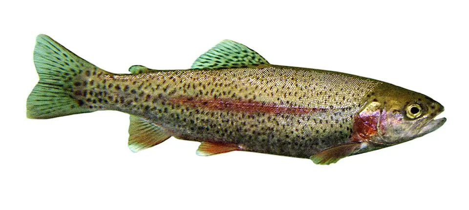
Identification
Rainbow Trout (Oncorhynchus mykiss) is the binomial used on the GBIF occurrences matched to these waterfalls, in the family Salmonidae (Salmoniformes).
The common name “Rainbow Trout” is the USGS NAS species-level name for Oncorhynchus mykiss.
The name on each matched record resolves to this binomial. Subspecies and varieties were rolled up to the species. Genus-only identifications were not counted. The GBIF taxon page is Oncorhynchus mykiss on GBIF.
Waterfalls where it is recorded
Each row is a published waterfall whose nearest named USGS hydrography flowline is the stream in the record, with the flowline within 500 m of the falls and the occurrence within 5 km. Read every row as “recorded in [stream] near [falls].”
| Waterfall | Stream | Records | Years | Distance | Name matched in |
|---|---|---|---|---|---|
| Elk Creek Falls Orofino, Idaho | Elk Creek GNIS 381347 | 24 | 2005–2011 | 4.2 km | locality (24) Example: ELK CREEK RESERVOIR |
| Gooseberry Falls Two Harbors, Minnesota | Gooseberry River GNIS 656415 | 16 | 2005–2011 | 1.3 km | locality (16) Example: Gooseberry River waterbody |
| Illgen Falls Silver Bay, Minnesota | Baptism River GNIS 639621 | 14 | 2005–2013 | 1.8 km | locality (14) Example: Baptism River, Downstream of State Highway 1, 2 miles NE of Illgen City |
| Gilmer Falls Keshena, Wisconsin | Red River GNIS 1572151 | 8 | 2006–2011 | 1–2.4 km | locality (8) Example: Red River in Shawano County |
| Ramsey Falls Redwood Falls, Minnesota | Ramsey Creek GNIS 649804 | 6 | 2006–2011 | 1.4 km | locality (6) Example: Ramsey Creek waterbody |
| Cascade Falls Grand Marais, Minnesota | Cascade River GNIS 655660 | 5 | 2005–2010 | 0.2 km | locality (5) Example: Cascade River waterbody |
| Rumford Falls Mexico, Maine | Androscoggin River GNIS 580918 | 5 | 2007–2011 | 1.5 km | locality (5) Example: Androscoggin River near Mexico in Oxford County |
| Cascades Pembroke, Virginia | Little Stony Creek GNIS 1484986 | 4 | 2007 | 2–4.7 km | locality (4) Example: Little Stony Creek, Site 9 (Hitt and Roberts 2005-2007 study) |
| Jemez Falls Jemez Pueblo, New Mexico | East Fork Jemez River GNIS 918170 | 4 | 2005 | 3.8 km | locality (4) Example: East Fork Jemez River, above confluence with San Antonio Creek, Battleship Rock Day Use Area. |
| Ribbon Falls Grand Canyon Village, Arizona | Bright Angel Creek GNIS 00001962 | 3 | 2013 | 1.9–4.7 km | locality (3) Example: Bright Angel Creek |
| Big Falls Malmstrom Air Force Base, Montana | Missouri River GNIS 756398 | 1 | 2006 | 2.4 km | locality (1) Example: Box Elder Creek, confluence with the Missouri River |
| Brandywine Falls Boston Heights, Ohio | Brandywine Creek GNIS 1066599 | 1 | 2008 | 0.6 km | locality (1) Example: Brandywine Creek, at about RM 1.5, township |
| Dillon Falls Deschutes River Woods, Oregon | Deschutes River GNIS 1140916 | 1 | 2024 | 4.9 km | verbatim locality (1) Example: Deschutes River, Bend, OR, US |
| Lava Island Falls Deschutes River Woods, Oregon | Deschutes River GNIS 1140916 | 1 | 2024 | 1.5 km | verbatim locality (1) Example: Deschutes River, Bend, OR, US |
| Potato River Falls Hurley, Wisconsin | Potato River GNIS 1571834 | 1 | 2009 | 3.9 km | locality (1) Example: Potato River |
| Sandusky Falls Sandusky, Ohio | Cold Creek GNIS 1039237 | 1 | 2013 | 4.4 km | locality (1) Example: Cold Creek, at Castalia Fish Hatchery, 1.2 miles north of Castalia OH, Margaretta township |
Native or nonindigenous status
USGS NAS lists the species-level record as “Native”. That label describes the NAS species record, which can be native in part of the country and introduced elsewhere. The fact sheet is NAS species 910. Counts below are NAS introduction records, not the GBIF counts in the table above.
| State | NAS nonindigenous records | Statuses in the sample | Years in the sample |
|---|---|---|---|
| AZ | 100 | established, stocked | 1880–2002 |
| ID | 100 | established, stocked | 1941–2007 |
| ME | 100 | established, stocked | 1914–2011 |
| MN | 100 | established, extirpated, stocked | 1888–1999 |
| MT | 100 | established, stocked, unknown | 1920–2012 |
| NM | 53 | stocked, established, failed | 1957–2025 |
| OH | 100 | established, stocked | 1885–2025 |
| OR | 100 | established, stocked, unknown | 1928–2003 |
| VA | 65 | stocked, established | 1945–2026 |
| WI | 100 | established, stocked | 1888–1995 |
NAS public responses are capped, so statuses and years describe the records returned (up to 100 per state), while the count is the number NAS reported. A state with no NAS row is not marked native.
Fishing rules in these states
These links go to the state agency fishing pages, reviewed 2026-11-19. Seasons, limits, and which streams are open change, and a waterfall record is not a statement that fishing is legal there.
- Arizona fishing regulations
- Idaho fishing regulations
- Maine fishing regulations
- Minnesota fishing regulations
- Montana fishing regulations
- New Mexico fishing regulations
- Ohio fishing regulations
- Oregon fishing regulations
- Virginia fishing regulations
- Wisconsin fishing regulations
Sources for the occurrence counts
- GBIF dataset — 87 matched records, via GBIF (CC0 1.0 or CC BY 4.0 or CC BY 3.0 or CC BY 2.0 only).
- GBIF dataset — 2 matched records, via GBIF (CC0 1.0 or CC BY 4.0 or CC BY 3.0 or CC BY 2.0 only).
- Fishes of Texas Project — 2 matched records, via GBIF (CC0 1.0 or CC BY 4.0 or CC BY 3.0 or CC BY 2.0 only).
- iNaturalist research-grade observations — 2 matched records, via GBIF (CC0 1.0 or CC BY 4.0 or CC BY 3.0 or CC BY 2.0 only).
- GBIF dataset — 1 matched record, via GBIF (CC0 1.0 or CC BY 4.0 or CC BY 3.0 or CC BY 2.0 only).
- GBIF dataset — 1 matched record, via GBIF (CC0 1.0 or CC BY 4.0 or CC BY 3.0 or CC BY 2.0 only).
Accessed 2026-11-19. Records before 2005, records with coordinate uncertainty over 5 km, and records whose license was not CC0 or CC BY were excluded. Please cite the original datasets if you reuse the figures.
Frequently Asked Questions
Where has Rainbow Trout been recorded near waterfalls on this site?
In Elk Creek near Elk Creek Falls, ID; Gooseberry River near Gooseberry Falls, MN; Baptism River near Illgen Falls, MN; Red River near Gilmer Falls, WI; and 12 more published falls. Each match is a CC0 or CC BY occurrence from 2005–2024 that names the stream and falls within 5 km of the mapped waterfall.
Does that mean Rainbow Trout lives in those waterfalls?
No. The records show the species was recorded in the named stream near the falls. They do not show which side of the drop the animal was on, and they are not a population estimate.
Is Rainbow Trout native in these states?
USGS NAS has nonindigenous records in AZ, ID, ME, MN, MT, NM, OH, OR, VA, WI. See the status table for the statuses NAS publishes, such as established or failed.
Can you fish for Rainbow Trout at these waterfalls?
License and season rules are set by the state, not by this site. Agency pages we checked on 2026-11-19: Arizona (https://www.azgfd.com/fishing/); Idaho (https://idfg.idaho.gov/fish); Maine (https://www.maine.gov/ifw/fishing-boating/fishing/index.html); Minnesota (https://www.dnr.state.mn.us/fishing/index.html); Montana (https://fwp.mt.gov/fish); New Mexico (https://www.wildlife.state.nm.us/fishing/); Ohio (https://ohiodnr.gov/buy-and-apply/hunting-fishing-boating/fishing-resources); Oregon (https://myodfw.com/fishing); Virginia (https://dwr.virginia.gov/fishing/); Wisconsin (https://dnr.wisconsin.gov/topic/Fishing). Confirm the water is open and what gear is legal before you fish.
Which datasets are these counts from?
GBIF dataset (87 records); GBIF dataset (2 records); Fishes of Texas Project (2 records); iNaturalist research-grade observations (2 records); GBIF dataset (1 record); GBIF dataset (1 record). All of those rows reached us through GBIF under a CC0 or CC BY license. Dataset pages: https://www.gbif.org/dataset/d6cc311c-c5ab-4f23-9a20-10514f9eb9c4, https://www.gbif.org/dataset/a2254f58-8bbf-41e6-ac4e-03d1683e0ce5, https://www.gbif.org/dataset/ba5b0f3a-73dd-459f-a7f1-9abc327aed00, https://www.gbif.org/dataset/50c9509d-22c7-4a22-a47d-8c48425ef4a7, https://www.gbif.org/dataset/93c707dc-4708-47fc-93d8-424702116442, https://www.gbif.org/dataset/813b435e-f762-11e1-a439-00145eb45e9a.