
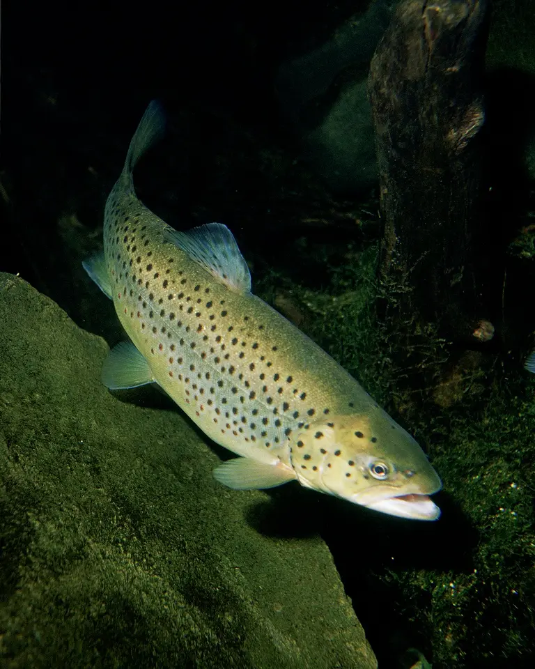
Identification
Brown Trout (Salmo trutta) is the binomial used on the GBIF occurrences matched to these waterfalls, in the family Salmonidae (Salmoniformes).
The common name “Brown Trout” is the USGS NAS species-level name for Salmo trutta.
The name on each matched record resolves to this binomial. Subspecies and varieties were rolled up to the species. Genus-only identifications were not counted. The GBIF taxon page is Salmo trutta on GBIF.
Waterfalls where it is recorded
Each row is a published waterfall whose nearest named USGS hydrography flowline is the stream in the record, with the flowline within 500 m of the falls and the occurrence within 5 km. Read every row as “recorded in [stream] near [falls].”
| Waterfall | Stream | Records | Years | Distance | Name matched in |
|---|---|---|---|---|---|
| Pumgustuck Yarmouth, Maine | Royal River GNIS 574564 | 41 | 2005–2011 | 1.7–4.4 km | locality (41) Example: Royal River near Yarmouth in Cumberland County |
| Apple River Falls Somerset, Wisconsin | Apple River GNIS 1581583 | 13 | 2006–2012 | 3 km | locality (13) Example: Apple River in St. Croix County |
| Rumford Falls Mexico, Maine | Androscoggin River GNIS 580918 | 8 | 2006–2011 | 1.5 km | locality (8) Example: Androscoggin River near Mexico in Oxford County |
| Gilmer Falls Keshena, Wisconsin | Red River GNIS 1572151 | 7 | 2006–2011 | 1–2.4 km | locality (7) Example: Red River in Shawano County |
| Ramsey Falls Redwood Falls, Minnesota | Ramsey Creek GNIS 649804 | 7 | 2005–2011 | 1.4 km | locality (7) Example: Ramsey Creek waterbody |
| Jemez Falls Jemez Pueblo, New Mexico | East Fork Jemez River GNIS 918170 | 4 | 2005 | 3.8 km | locality (4) Example: San Antonio Creek, above confluence with East Fork Jemez River, at Battleship Rock Day Use area. |
| Eighteenfoot Falls Niagara, Wisconsin | North Branch Pike River GNIS 1570390 | 3 | 2011 | 2.1–4.3 km | locality (3) Example: North Branch Pike River |
| Ribbon Falls Grand Canyon Village, Arizona | Bright Angel Creek GNIS 00001962 | 3 | 2013 | 1.9–4.7 km | locality (3) Example: Bright Angel Creek |
| Big Manitou Falls Superior, Wisconsin | Black River GNIS 1561881 | 2 | 2006 | 3.5 km | locality (2) Example: Black River in Douglas County |
| Horseshoe Falls Niagara, Wisconsin | South Branch Pike River GNIS 1574412 | 2 | 2006–2011 | 2.1–3.5 km | locality (2) Example: South Branch Pike River |
| Little Manitou Falls Superior, Wisconsin | Black River GNIS 1561881 | 2 | 2006 | 4.7 km | locality (2) Example: Black River in Douglas County |
| Bridal Veil Falls Franklin, North Carolina | Cullasaja River GNIS 1010609 | 1 | 2013 | 1.9 km | locality (1) Example: Cullasaja River, upstream of Turtle Pond Road [SR1620], 5.35 km NW of Highlands |
| Cullasaja Falls Franklin, North Carolina | Cullasaja River GNIS 1010609 | 1 | 2013 | 4.9 km | locality (1) Example: Cullasaja River, upstream of Turtle Pond Road [SR1620], 5.35 km NW of Highlands |
| Daves Falls Niagara, Wisconsin | Pike River GNIS 1571390 | 1 | 2007 | 0.4 km | locality (1) Example: Pike River |
| Dry Falls Franklin, North Carolina | Cullasaja River GNIS 1010609 | 1 | 2013 | 1.3 km | locality (1) Example: Cullasaja River, upstream of Turtle Pond Road [SR1620], 5.35 km NW of Highlands |
| Horsetail Fall Yosemite Valley, California | Merced River GNIS 272412 | 1 | 2024 | 4.7 km | verbatim locality (1) Example: Merced River, Coulterville, CA, US |
| Morrell Falls Seeley Lake, Montana | Morrell Creek GNIS 787696 | 1 | 2005 | 4.8 km | locality (1) Example: Morrell Creek |
| Nevada Fall Yosemite Valley, California | Merced River GNIS 00272412 | 1 | 2024 | 4.3 km | verbatim locality (1) Example: Merced River, Coulterville, CA, US |
| Saxon Falls Ironwood, Michigan | Montreal River GNIS 1579905 | 1 | 2011 | 4.3 km | locality (1) Example: Montreal River in Iron County |
| Strong Falls Niagara, Wisconsin | Peshtigo River GNIS 1580126 | 1 | 2011 | 1.2 km | locality (1) Example: Peshtigo River |
| Superior Falls Hurley, Wisconsin | Montreal River GNIS 1579905 | 1 | 2011 | 0.3 km | locality (1) Example: Montreal River in Iron County |
| Vernal Fall Yosemite Valley, California | Merced River GNIS 00272412 | 1 | 2024 | 3.1 km | verbatim locality (1) Example: Merced River, Coulterville, CA, US |
| Wiley Falls Jarrettsville, Maryland | Deer Creek GNIS 584079 | 1 | 2008 | 0.5 km | locality (1) Example: Deer Creek |
Native or nonindigenous status
USGS NAS lists the species-level record as “Exotic”. That label describes the NAS species record, which can be native in part of the country and introduced elsewhere. The fact sheet is NAS species 931. Counts below are NAS introduction records, not the GBIF counts in the table above.
| State | NAS nonindigenous records | Statuses in the sample | Years in the sample |
|---|---|---|---|
| AZ | 100 | established, unknown, stocked | 1880–2025 |
| CA | 100 | established, failed, unknown | 1884–2003 |
| MD | 100 | established, stocked | 1903–2000 |
| ME | 100 | established, stocked, unknown | 1885–2009 |
| MI | 100 | established, failed, unknown, stocked | 1903–2005 |
| MN | 100 | established, stocked | 1920–2005 |
| MT | 100 | established | 1889–2006 |
| NC | 100 | established, unknown, stocked | 1980–2011 |
| NM | 36 | established, stocked, unknown | 1920–2025 |
| WI | 100 | established, stocked | 1903–2010 |
NAS public responses are capped, so statuses and years describe the records returned (up to 100 per state), while the count is the number NAS reported. A state with no NAS row is not marked native.
Fishing rules in these states
These links go to the state agency fishing pages, reviewed 2026-11-19. Seasons, limits, and which streams are open change, and a waterfall record is not a statement that fishing is legal there.
- Arizona fishing regulations
- California fishing regulations
- Maryland fishing regulations
- Maine fishing regulations
- Michigan fishing regulations
- Minnesota fishing regulations
- Montana fishing regulations
- North Carolina fishing regulations
- New Mexico fishing regulations
- Wisconsin fishing regulations
Sources for the occurrence counts
- GBIF dataset — 94 matched records, via GBIF (CC0 1.0 or CC BY 4.0 or CC BY 3.0 or CC BY 2.0 only).
- Auburn University Museum Fish Collection — 3 matched records, via GBIF (CC0 1.0 or CC BY 4.0 or CC BY 3.0 or CC BY 2.0 only).
- iNaturalist research-grade observations — 3 matched records, via GBIF (CC0 1.0 or CC BY 4.0 or CC BY 3.0 or CC BY 2.0 only).
- GBIF dataset — 2 matched records, via GBIF (CC0 1.0 or CC BY 4.0 or CC BY 3.0 or CC BY 2.0 only).
- Fishes of Texas Project — 2 matched records, via GBIF (CC0 1.0 or CC BY 4.0 or CC BY 3.0 or CC BY 2.0 only).
Accessed 2026-11-19. Records before 2005, records with coordinate uncertainty over 5 km, and records whose license was not CC0 or CC BY were excluded. Please cite the original datasets if you reuse the figures.
Frequently Asked Questions
Where has Brown Trout been recorded near waterfalls on this site?
In Royal River near Pumgustuck, ME; Apple River near Apple River Falls, WI; Androscoggin River near Rumford Falls, ME; Red River near Gilmer Falls, WI; and 19 more published falls. Each match is a CC0 or CC BY occurrence from 2005–2024 that names the stream and falls within 5 km of the mapped waterfall.
Does that mean Brown Trout lives in those waterfalls?
No. The records show the species was recorded in the named stream near the falls. They do not show which side of the drop the animal was on, and they are not a population estimate.
Is Brown Trout native in these states?
USGS NAS has nonindigenous records in AZ, CA, MD, ME, MI, MN, MT, NC, NM, WI. See the status table for the statuses NAS publishes, such as established or failed.
Can you fish for Brown Trout at these waterfalls?
License and season rules are set by the state, not by this site. Agency pages we checked on 2026-11-19: Arizona (https://www.azgfd.com/fishing/); California (https://wildlife.ca.gov/Fishing); Maryland (https://dnr.maryland.gov/fisheries/pages/default.aspx); Maine (https://www.maine.gov/ifw/fishing-boating/fishing/index.html); Michigan (https://www.michigan.gov/dnr/things-to-do/fishing); Minnesota (https://www.dnr.state.mn.us/fishing/index.html); Montana (https://fwp.mt.gov/fish); North Carolina (https://www.ncwildlife.gov/fishing); New Mexico (https://www.wildlife.state.nm.us/fishing/); Wisconsin (https://dnr.wisconsin.gov/topic/Fishing). Confirm the water is open and what gear is legal before you fish.
Which datasets are these counts from?
GBIF dataset (94 records); Auburn University Museum Fish Collection (3 records); iNaturalist research-grade observations (3 records); GBIF dataset (2 records); Fishes of Texas Project (2 records). All of those rows reached us through GBIF under a CC0 or CC BY license. Dataset pages: https://www.gbif.org/dataset/d6cc311c-c5ab-4f23-9a20-10514f9eb9c4, https://www.gbif.org/dataset/d499aef2-b1d9-4890-aeb3-5f0d1237b513, https://www.gbif.org/dataset/50c9509d-22c7-4a22-a47d-8c48425ef4a7, https://www.gbif.org/dataset/a2254f58-8bbf-41e6-ac4e-03d1683e0ce5, https://www.gbif.org/dataset/ba5b0f3a-73dd-459f-a7f1-9abc327aed00.